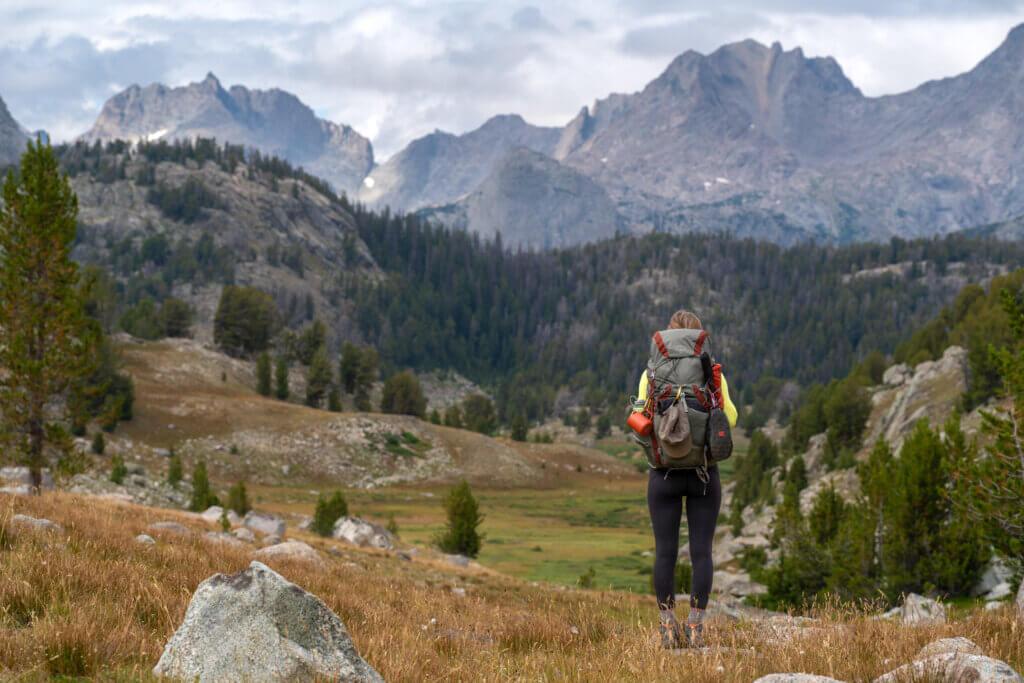
The Wind River Range is a unique piece of the Rocky Mountains that encompasses an area of over 2 million acres of mountainous land in Western Wyoming. “The Winds” as they are often referred as, are home to hundreds of remote trails, alpine meadows, towering granite peaks, pristine alpine lakes, and breathtaking scenery. One of the most “famous” sections of the Wind River Range is the 25 mi multi-day backpacking loop called “Cirque of the Towers”.
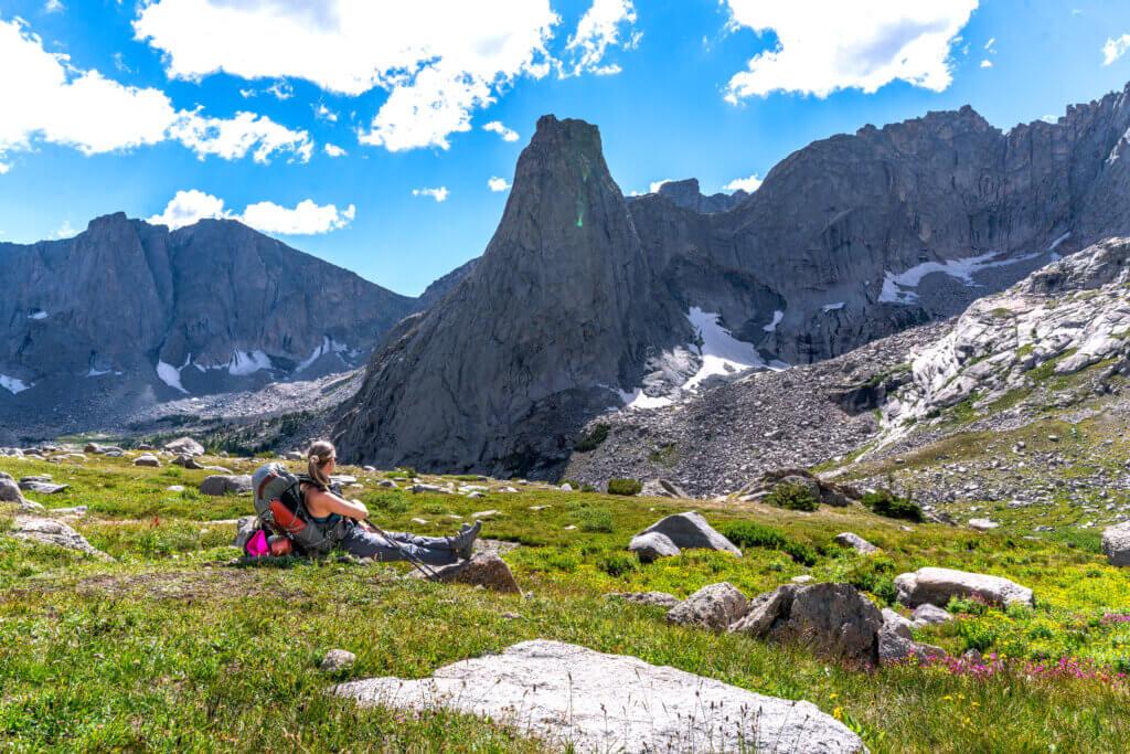
The highlight of the loop, and the part that attracts backpackers and climbers from all over- is the Cirque itself. The Cirque is a stunning amphitheater of granite peaks that stand over 12,000 ft tall including the iconic Pingora, Wolf’s Head, and Lizard Head Peak. It is one of the most beautiful ranges in the world and worth every single step it takes to see it!
Alright, I KNOW you’re here for beta on how to backpack the Cirque of the Towers Loop, so let’s just go ahead and dive right in!
Contents
| ***Disclosure: This post contains affiliate links. If you click one of them, I may receive a small commission (for which I am very grateful for) at no extra cost to you. |
How to get to the Cirque of the Towers Loop?
The Cirque of the Towers loop begins at the trailhead, Big Sandy. Big Sandy is located about 3 hr SE of Grand Teton National Park in a very remote region of Wyoming. The road that you drive to access the trailhead has no services, no cell phone reception, and no town access. The closest town is Pinedale which is about a 2-hr. drive from the trailhead. It is SO important that you fill up on gas and grab any other essential before leaving Pinedale, so you don’t find yourself in a predicament later!
Let’s talk about the road conditions.
Some people/blogs say that you MUST have a high clearance/4wd to access the trailhead, but I completely disagree with that sentiment. Passenger cars can make it OK if driven carefully. The last 6-8 miles are a little rough, but nothing a FWD can’t handle. I would be a little weary in muddy conditions, but overall, not bad if you take it slow and easy. Check with the Pinedale ranger station before starting your trip to learn about current road and trail conditions.
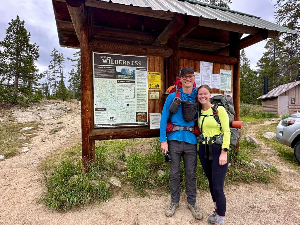
Permitting & Trail Regulations
One of the best parts about this trail is that it does NOT require a permit! Which means you don’t have to plan your trip months in advance or HOPE to get a permit from the lottery. You will, however, have to fill out the registrar at the trailhead with your name and trip dates, but this is just used by the Forest Service to monitor trail traffic and backcountry usage.
PSA: DOGS ARE ALLOWED ON TRAIL!!! It’s so rare to have an epic backpacking trip (or any backpacking trip) that allows dogs, and we want to KEEP IT THAT WAY. So please if you plan to bring your pup, pick up after them and follow all Leave No Trace Principles.
Regulations:
- The max # of people in each group is 15
- Max length of stay is 15 consecutive days at 1 site
- All campsites must be located at least 200 ft away from lakeshores or system trails, and 100 ft from streams, creeks, or springs
- Shortcutting trail switchbacks is not allowed
- Cutting or removing standing wood is prohibited
- Camping at Lonesome Lake is CLOSED. Camping within ¼ of a mile from Lonesome Lake is prohibited. Also the water from lonesome lake is NOT safe to drink, even if treated.
- LEAVE NO TRACE!
Best Time to Backpacking the Cirque of the Towers
This area of the Winds can be prone to big winters with heavy snowfall so anytime from October-June/July is pretty much a no-go. Around the June/July time the snow should start to become manageable BUT, the mosquitos and flies are HORRENDOUS this time of year and can really put a damper on your trip. I pretty much always suggest mid to late August for your Wind River Range Backpacking trip because the bugs aren’t as much of an issue and the weather is warm during the day but cool in the evening making for perfect camping weather.
Also, keep in mind that if you wait too long and plan your trip for Sep/Oct you are risking running into a random early season snowstorm which would cancel your trip entirely.
Cirque of the Towers Backpacking Loop Stats
- Total mileage: 26 mi loop (unless you do some side-exploring)
- Big Sandy Trailhead elevation: 9,000 ft
- Elevation gain: 4,000 ft
- Highest elevation: 11,500 (Texas Pass)
- Difficulty: Strenuous
The Cirque of the Towers loop has consistent rolling hills and rocky terrain. There are 2 mountain passes you will climb throughout the loop, Texas Pass & Jackass Pass. These are very steep and a little bit of a slog to get to over, especially Texas Pass. The passes are the toughest sections of the backpacking loop so it’s good to be mindful of them.
What to Bring on the Loop?
For a full list of our backpacking “must-haves” check out backpacking gear guide & and recommendations! Bust specific to the Cirque of the Towers Loop you will need the following:
Bear canister: A MUST HAVE! Both black bears and grizzly bears are active in the Wind River Range. You’ll need to carry a bear canister to protect your food from getting hijacked by the bears & critters on the trail.
Bear spray: Carrying bear spray is not mandatory, but it is best practice. Bear spray will give you peace of mind in the off chance you come face to face with a bear on the trail.
Satellite phone: There is NO SERVICE out there and you never know when/if you’ll encounter an emergency on the trail. You should ALWAYS carry a satellite gps device with you in the backcountry. We use the Garmin inreach mini 2 and LOVE it!
Water Filter: You must filter (or boil) all water you get from the lakes, streams, rivers along the loop. The sawyer squeeze is super packable and gets the job done.
Bug spray: The bugs are gnarly out there. Carry a small thing of bug spray even if you’re not prone to getting bit.
Offline map: We use alltrails for our trail map although it’s not always 100% reliable. It is best used as a reference.
Waste System: You’ll need to bring either a trowel system or wag bag for your waste. If you go for the trowel be sure to bring a paper bag to pack out your TP.
Cirque of the Towers 3-day, 2-night Itinerary
I want to preface this section with this: You do not have to follow this exact itinerary… you can camp just about anywhere on this loop!! This is a rough guide based on what we did and enjoyed and/or what we would have changed. Feel free to modify the mileage and camp sites based on your group’s ability and the amount of time you plan to spend on the trek!
Day 1: Big Sandy Trailhead to Shadow Lake
Mileage: 10 mi
Elevation gain~ 1,700 ft
Day one will begin at Big Sandy trailhead where you’ll register at the post and set out on your way! Most of today’s terrain is a moderate & gradual gain, which is a nice way to get your trail legs underneath you. You’ll pass multiple lakes, and beautiful meadows along the way so be sure to stop and enjoy your surroundings as much as you please!
There are also a bunch of campsites you’ll pass on the way to Shadow Lake. If you are hopeful to have some solitude for the night, then you may want to stop a little before the lake at one of the many beautiful camp spots you come across. If you opt to continue onward to Shadow Lake for the night, you will probably have neighbors… BUT the view at the lake is phenomenal and SO worth it!
Day 2: Shadow Lake to Lonesome Lake OR Big Sandy Lake
Mileage to Lonesome Lake: 5
Elevation Gain to Lonesome Lake: ~1,200 ft
Mileage to Big Sandy Lake: 9
Elevation Gain to Big Sandy: ~ 2,000 ft
Day 2 is going to be the toughest day of your trek and therefore I wanted to present 2 different options for you to choose from! No matter which option you choose, Texas pass is the first obstacle you’ll tackle after your hike out from Shadow Lake. Texas pass is steep, rocky, and brutal to be honest, but once at the top you’ll be rewarded with the BEST view on the entire trek!
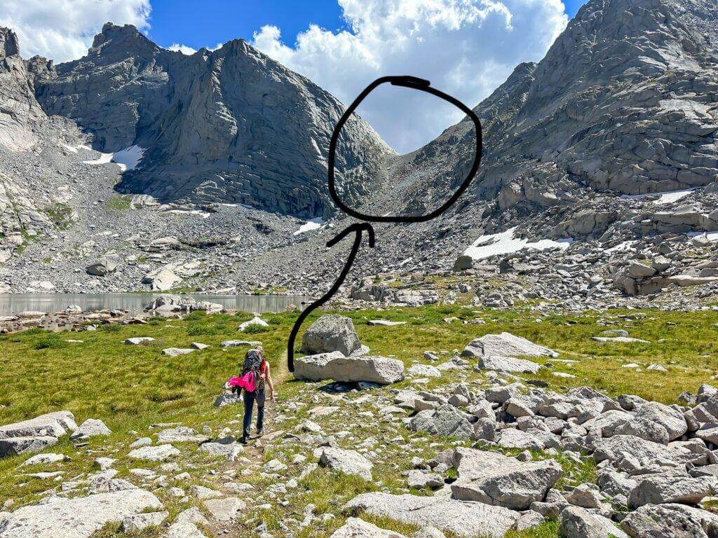
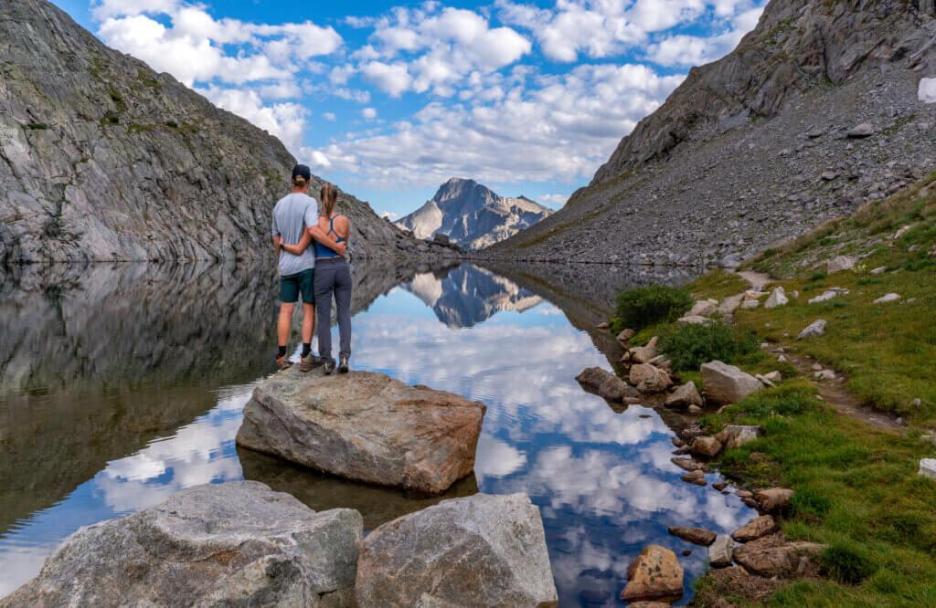
Right over the pass is a panoramic view of the Cirque. The Cirque is a stunning amphitheater of granite peaks that stand over 12,000 ft tall including the iconic Pingora, Wolf’s Head, and Lizard Head Peak. You’ll spend the next couple of miles up close and personal with the Cirque as you descend the steep valley on the other side of Texas Pass. Take a snack break and ENJOY the view! It is truly one of the most beautiful places I’ve ever been.
After Texas Pass you can choose to set up camp in the meadow on the backside of Lonesome Lake (taking in mind to not camp within ¼ of a mile from Lonesome Lake itself per the Forest Service’s regulations). OR you can continue onward over Jackass Pass. If you choose to continue and go over the second pass, just know that there are limited camping options until you get to Big Sandy Lake, therefore you’re basically committing to the mileage it takes to get to Big Sandy. SOMETIMES you can find some dispersed camp spots near Arrowhead Lake or North Lake, but you definitely cannot rely on that.
Day 3: Lonesome Lake OR Big Sandy Lake to Big Sandy Trailhead
Mileage from Lonesome Lake: 10
Elevation Gain from Lonesome: 1400 ft
Mileage from Big Sandy Lake: 6 mi
Elevation Gain from Big Sandy: 600 ft
After 2 incredible nights of sleeping under the stars it’s time to pack up camp for the last time and start your trek back to Big Sandy Trailhead. Today’s mileage is relatively short if you opt to camp at Big Sandy Lake, therefore it’s nice to have a slow morning and cook a yummy breakfast before heading out. Subsequently, if you start your day near Lonesome, you’ve got a bigger day ahead and might want to get an early start.
Either way, once you pass the entirety of Big Sandy Lake, you’ll be back in the forest for the rest of the hike until the trail spits you out right where you started 2 mornings ago!
***Now, this is probably the BEST tip I’ll give you in this entire article… on your way back towards civilization be SURE to stop at Big Sandy Lodge for the freshest & most delicious farm to table burger you will ever eat!!! PLUS, they offer a few beers on the menu which is a great way to celebrate finishing the Cirque of the Towers backpacking loop! Just don’t drink too many if you’re the one driving!
Know Before You Go
The Night Before
The trailhead is located far from any civilization, so I always suggest driving to the trailhead the night before your trip and either car camping at the trailhead or tent camping a little further out on the BLM Land (what is blm land)? ESPECIALLY if your trip is on a weekend because parking at the trailhead is limited.
Parking
Speaking of parking… let’s talk about it! The parking lot at the trailhead is small, but if you can’t find parking when you first get there, be patient. There are always hikers coming in and out of the lot especially during high season. When you do find a spot, please lock your car, and don’t leave any valuables behind. Break-ins don’t happen very often, but it’s better to be safe than sorry!
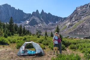
Camping on the Cirque of the Towers Loop
You can basically camp anywhere along the trail if you are within the trail regulations as stated above, but because of the fragile landscape, you should practice minimal impact camping techniques. This basically means to camp in a spot that has already been cleared for camping… don’t create a “new” tent spot.
Water Sources on the Cirque of the Towers Loop
There is a plethora of water sources along the trail- lakes, streams, rivers, ect. Most of the water is considered safe to drink, but it is best practice to use a water filter. We always take our sawyer filter with us on any backpacking trip.
*** the water from lonesome lake is NOT safe to drink, even if treated***
Critters on the Cirque of the Towers Loop
The main critters you’ll want to be on the lookout for are bears (black & grizzly), marmots, biting flies, & mosquitos.
The Wind River Range DEFINITLEY has active bears in the area. Be sure you know “what to do if you encounter a bear on the trail” and always carry bear spray with you.
The marmots are probably going to be your worst enemy. They’re cute on the outside, but absolutely ruthless on the inside. They will tear through your bag or tent to get to your food if you leave it out. Please do not feed them.
Weather in the Wind River Range
The weather can be super unpredictable in the mountains, especially in the Wind River Range. The forecast will give you a good idea of what’s coming, but there’s always the chance of afternoon thunderstorms so just come prepared! Rain gear & pack covers will do wonders.
Also, be sure to tackle the passes (Texas and Jackass) early in the morning so you don’t get caught on the ridgeline in an unpredicted afternoon lightning storm.
Altitude
Big Sandy trailhead sits at around 9,000 ft, which is high especially if you’re coming from sea level. If you’ve never been exposed to altitude, you should try and sleep at the trailhead 1-2 nights prior to your trip to acclimate. If you don’t have extra time in your itinerary, then be sure to drink plenty of water and take it slow while hiking! Mild altitude sickness isn’t dangerous, but it can be miserable.
Clockwise or Counterclockwise?
Technically you can hike the loop either clockwise OR counterclockwise, but I would suggest going clockwise. The elevation gain is milder when hiking clockwise and the views are much more dramatic!


1 thought on “Backpacking Cirque of the Towers in the Wind River Range”
Once across the divide, the rules change. Within (200) two hundred feet of any trail, lake, or stream, not 100 (that is for Bridger). The East side is governed by the Shoshone NF.
“Pursuant to 36 CFR, Section 261.50(a) and (b), the following acts are prohibited on National Forest Wilderness areas within the Shoshone National Forest.
1.Camping. 36 CFR 261.58(e)
a. Within (50) fifty feet of any Forest Development Trail in the
North Absaroka Wilderness and Washakie Wilderness.
b. Within (100) one hundred feet of any trail, lake, or stream that is
indicated with a solid blue line on USGS topographic maps in the
Fitzpatrick Wilderness.
c. Within (200) two hundred feet of any trail, lake, or stream that is
indicated with a solid blue line on USGS topographic maps in the
Popo Agie Wilderness and Absaroka – Beartooth Wilderness.
d Within (1/4) one fourth mile of Lonesome Lake in the Popo Agie
Wilderness.”